Project Overview
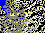
Flood Plain Images
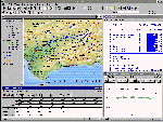
Screen Shots
Flood
Plain Overflight (VRML:
819kb)

| LNK developed real time simulation and visualization using digital source data provided by NASA regional application centers (RACs). Research objectives included reconstruction of a sample flood plain, examination of algorithms to represent dynamic changes to the terrain surface, evaluation of DoD systems and standards for applicability to flood hazard modeling. |
|
Project Overview
|
Flood Plain Images
|
|
Screen Shots
|
Flood
Plain Overflight (VRML:
819kb)
|